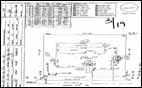
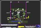
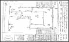
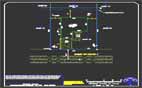
DimensionI GIS is an offshore value added service provider! It specialises in undertaking GIS contracting services like GIS conversion, GIS Mapping, Digital Image Processing, Remote Sensing, Rectification of Orthophotographs, Application Development, Conversion of manual maps to GIS etc... the company at the forefront of technological progress in GIS and have skilled process engineering teams & consultants, using streamlined systems and processes to ensure the best quality and accurate results to a worldwide clientele.
We have been providing GIS map conversion services to companies in the telecommunication; Mining, Survey, Municipal, utility sectors to help them in effectively administer their vast resources.
Our highly skilled and experienced staff uses state of the art software to produce extremely high quality work. This together with reliable communications, timely deliveries and long working hours our high volume resources in India make us an extremely Cost Effective Preferred Alternative.
|